热带风暴“伊萨亚斯”在墨西哥湾生成 预计将升级为飓风扑向美国沿海Tropical Storm Isaias Forms in Gulf, Forecast to Strike U.S. Coast as Hurricane
2026年10月7日清晨,热带风暴“伊萨亚斯”在墨西哥湾形成,成为2026年大西洋飓风季的第9个命名风暴。美国国家飓风中心表示,该系统预计将在温暖洋面上迅速增强,于10月8日达到1级飓风强度,并在10月9日接近美国墨西哥湾沿岸时增强为最大持续风速超过每小时100英里的2级飓风。气象部门预计,“伊萨亚斯”可能成为本季度首个飓风,并于10月9日周五或10月10日周六在路易斯安那州东南部至佛罗里达州狭长地带一带登陆,沿海地区将面临破坏性强风、风暴潮及局部高达10至12英寸的强降雨威胁。随着风暴逼近,佛罗里达州州长罗恩·德桑蒂斯已于10月6日签署行政令,宣布该州25个县进入紧急状态,以确保狭长地带和大弯曲地区的社区及时调配防灾资源。
Tropical Storm Isaias formed early Wednesday, Oct. 7, 2026, in the Gulf of Mexico, marking the ninth named storm of the 2026 Atlantic hurricane season. According to the National Hurricane Center, the system is forecast to rapidly intensify over open waters, becoming a Category 1 hurricane on Oct. 8 and strengthening into a Category 2 hurricane with winds exceeding 100 mph by Oct. 9 as it approaches the northern U.S. Gulf Coast. Forecasters expect Isaias to become the season's first hurricane, with a projected landfall between Friday, Oct. 9, and Saturday, Oct. 10, anywhere from southeastern Louisiana to the Florida Panhandle. The system is expected to bring dangerous wind gusts, coastal storm surge, and localized rainfall amounts between 10 and 12 inches. In response to the approaching threat, Florida Governor Ron DeSantis signed an executive order declaring a state of emergency for 25 counties to ensure resources are in place across the Panhandle and Big Bend regions.
01风暴生成与当前路径态势Storm Formation and Initial Trajectory
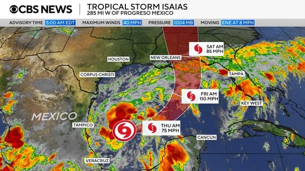
根据美国国家飓风中心10月7日发布的通报,热带风暴“伊萨亚斯”由第九号热带低气压增强而成,清晨时分位于墨西哥普罗格雷索以西约285英里(460公里)、密西西比河入海口西南约580英里(935公里)的墨西哥湾海域。该系统中心的最大持续风速约为每小时40英里(65公里),热带风暴强度风圈自中心向外延伸达45英里,正以每小时8英里(13公里)的速度向东北偏东方向移动。
According to National Hurricane Center advisories issued early Wednesday, Oct. 7, Tropical Storm Isaias developed from Tropical Depression Nine over the Gulf of Mexico. As of early morning reports, the storm's center was located roughly 285 miles (460 kilometers) west of Progreso, Mexico, and about 580 miles (935 kilometers) southwest of the mouth of the Mississippi River. The system packed maximum sustained winds of 40 mph (65 km/h), with tropical-storm-force winds extending outward up to 45 miles from the center, while moving east-northeast at approximately 8 mph (13 km/h).
气象预报显示,风暴将在10月8日周四掠过墨西哥尤卡坦半岛以北洋面,并在周四至周五期间转向东北及偏北方向移动,随后逐步逼近美国墨西哥湾北部沿海。国家飓风中心指出,该风暴在向沿海推进的过程中将给坎佩切湾沿海地区带来2至4英寸降雨,墨西哥坎佩切州和尤卡坦州西部局部降雨量可能更高。气象部门预计将于10月7日晚些时候针对美国北部沿海部分地区发布飓风观察预警。
Forecasters project that Isaias will pass north of Mexico's Yucatan Peninsula on Thursday, Oct. 8, before making a turn toward the northeast and north on Thursday and Friday as it approaches the northern U.S. Gulf Coast. The storm is expected to produce 2 to 4 inches of rain across coastal portions of the Bay of Campeche, with localized higher totals in the Mexican states of Campeche and western Yucatan. Forecasters noted that hurricane watches will likely be issued for portions of the northern Gulf Coast later Wednesday.
02迅速增强预测与首个飓风特征Rapid Intensification and Hurricane Projections
气象预报员预计,热带风暴“伊萨亚斯”在墨西哥湾开阔水域上空将经历快速增强过程。美国国家飓风中心分析指出,风暴将在10月8日周四增强为1级飓风,并于10月9日接近沿岸前进一步发展为持续风速达到每小时110英里的2级飓风。气象专家预计风暴将在登陆前达到强度峰值,并在向陆地靠拢时保持具有重大破坏力的飓风级别,随后在深入内陆后急剧减弱。
Forecasters project that Tropical Storm Isaias will undergo rapid intensification over the warm, open waters of the Gulf of Mexico. According to specialists at the National Hurricane Center, the system is expected to strengthen into a Category 1 hurricane on Thursday, Oct. 8, before escalating into a Category 2 hurricane with maximum sustained winds of 110 mph on Oct. 9. Specialists noted that the storm is forecast to peak in intensity over water before reaching the coast, maintaining significant hurricane strength upon arrival before dramatically weakening as it moves inland.
“伊萨亚斯”的形成在2026年大西洋飓风季中具有特殊气候背景。尽管正常年份通常会产生大约7个飓风,但本季在强厄尔尼诺现象抑制大西洋风暴生成的大环境下整体表现较为平静,且飓风季将于11月30日结束,风暴形成时剩余时间不足两个月。“伊萨亚斯”由此成为该季度的首个飓风,也是第9个被命名的热带风暴。
The development of Isaias carries distinct meteorological significance within the 2026 Atlantic hurricane season, which has been unusually quiet due to a strong El Niño pattern disrupting storm formation in the basin. While a typical Atlantic season features around seven hurricanes, Isaias marks the very first hurricane and the ninth named storm of 2026, emerging with less than two months remaining before the season officially concludes on Nov. 30.
03潜在登陆区域、风雨影响与内陆蔓延Landfall Projections, Heavy Rainfall, and Inland Threat
气象机构对“伊萨亚斯”的潜在着陆点和冲击范围做出了详细测算。美国国家飓风中心指出,风暴中心预计在路易斯安那州东南部至佛罗里达州狭长地带之间登陆。沿海登陆点附近预计将出现每小时40至60英里的广泛阵风,并伴随危险的风暴潮。气象部门预计,从路易斯安那州东南部到佛罗里达州狭长地带的墨西哥湾北部沿海区域,总降雨量普遍在3至6英寸之间,局部降雨量可达10英寸。根据AccuWeather气象预报,阿拉巴马州南部和密西西比州南部的风暴登陆核心区降雨最为集中,累计降水量将达8至12英寸。
Meteorological agencies have outlined widespread wind and precipitation threats along the northern Gulf Coast as Tropical Storm Isaias nears landfall. The National Hurricane Center projects the storm's center could come ashore anywhere between southeastern Louisiana and the western Florida Panhandle, bringing widespread wind gusts of 40 to 60 mph near the coastline along with rising storm surges. Forecasters expect general rainfall totals of 3 to 6 inches, with isolated amounts reaching up to 10 inches across the northern Gulf Coast from far southeastern Louisiana through the Florida Panhandle. AccuWeather forecasters noted that the heaviest rain, totaling 8 to 12 inches, is projected across southern Alabama and southern Mississippi close to the storm's landfall zone.
风暴带来的强降雨和强风威胁将进一步向美国东南部及内陆地区延伸。气象预报显示,随着风暴向北移动朝阿巴拉契亚山脉挺进,阿拉巴马州大部和佛罗里达狭长地带将迎来4至8英寸降水,阿巴拉契亚高海拔地区可能面临局部严重内涝与泥石流威胁。雨带还将向北扩散至田纳西河谷、俄亥俄河谷的肯塔基州和西弗吉尼亚州,降雨量在1至3英寸之间,局部可达5英寸,随后向东推移进入南北卡罗来纳州和弗吉尼亚州南部,部分内陆和城市区域存在发生城市洪涝和停电风险。
The storm's moisture is expected to spread deeply into inland regions across the Southeast and toward the Ohio Valley over the weekend. Rainfall bands of 4 to 8 inches are forecast across much of Alabama and the Florida Panhandle as the system tracks northward toward the Appalachian Mountains, raising the risk of property damage, power outages, and localized mudslides at higher elevations. Precipitation totaling 1 to 3 inches, with localized amounts up to 5 inches, could extend northward into the Tennessee Valley, Kentucky, and West Virginia before sweeping eastward into the Carolinas and southern Virginia, creating flash flooding and urban flooding hazards across affected inland corridors.
04地方防灾响应与紧急状态部署Preparedness Measures and State of Emergency
为应对风暴逼近带来的天气威胁,佛罗里达州州长罗恩·德桑蒂斯于10月6日周二签署行政令,正式宣布该州25个县进入紧急状态。德桑蒂斯在声明中表示,该政令旨在确保佛罗里达州狭长地带和大弯曲地区的社区拥有充足的时间和资源,以全面做好应对潜在严重天气影响的准备工作。国家飓风中心与气象官员同时提醒从路易斯安那州到佛罗里达州狭长地带的沿海居民密切跟踪气象预警,及时落实防飓风应急预案。
To prepare for the storm's approaching hazards, Florida Governor Ron DeSantis signed an executive order on Tuesday, Oct. 6, declaring a state of emergency across 25 Florida counties. In a public statement, DeSantis noted that the measure ensures communities across the Florida Panhandle and Big Bend regions have the necessary time and operational resources to prepare for potential severe weather impacts. The National Hurricane Center and local emergency officials urged coastal residents from Louisiana through the Florida Panhandle to actively review safety plans and track ongoing meteorological advisories.
佛罗里达州部分地区当前的土壤饱和度加剧了防灾挑战。根据美国国家气象局塔拉哈西办公室的监测报告,佛州狭长地带多个县在本周早些时候已遭遇强降雨侵袭,其中阿巴拉契科拉累计降雨量已达11.84英寸,并在10月5日创下单日降雨7.49英寸的记录,追平了当地10月份的单日降雨历史极值。气象部门指出,持续降雨将增加该区域在“伊萨亚斯”登陆期间遭遇严重内涝的脆弱性,并提醒该州半岛沿海居民同步保持对风暴动态的警惕。
Emergency preparations take place against a backdrop of preexisting soil saturation across northern Florida. According to the National Weather Service office in Tallahassee, several counties across the Florida Panhandle experienced heavy downpours earlier in the week, with Apalachicola recording 11.84 inches of rain, including 7.49 inches on Oct. 5 that tied the city's single-day rainfall record for October. Forecasters warned that the already saturated ground heightens vulnerability to extensive flash flooding as Isaias moves ashore, prompting officials to advise residents along the Florida Peninsula to remain alert as well.