四级飓风“洛厄尔”逼近夏威夷Category 4 Hurricane Lowell Threatens Hawaii With Heavy Rain and Dangerous Surf
四级飓风“洛厄尔”(Lowell)正以每小时145英里的持续最大风速向夏威夷逼近,美国国家飓风中心预测该风暴将于9月7日周一晚间在主要岛屿西侧向北掠过,并维持强飓风强度。尽管风暴中心预计停留在近海,但其外围环流预计仍将为考艾岛和大岛带来局部超过10英寸的强降雨,茂宜岛局部降雨量或达8英寸,极易引发危险的山洪暴发与泥石流灾害。此外,考艾县可能面临1至3英尺的风暴潮并迎来热带风暴级大风,全州多处海岸线也将出现具有破坏力的巨浪与致命离岸流。 夏威夷州州长乔什·格林(Josh Green)与应急管理官员已敦促民众在周末完成防灾储备,州政府目前正同步采取加固港口设施、向重点区域预置应急响应人员以及严密监控水坝溢流等防灾举措。气象专家与应急部门同时提醒,飓风路径若发生轻微东偏,对夏威夷各岛特别是考艾岛的冲击将显著加剧,居民需严密关注官方预警并远离危险涉水区域。
Hurricane Lowell is advancing toward Hawaii as a major Category 4 hurricane carrying maximum sustained winds of 145 mph, with National Hurricane Center forecasts showing the storm curving northward just west of the main Hawaiian Islands late Monday night, September 7. Although forecasters expect the eye of the storm to remain offshore, the system is projected to trigger hazardous environmental conditions across the island chain, bringing isolated rainfall totals exceeding 10 inches to Kauai and the Big Island, up to 8 inches to Maui, and raising severe risks of flash flooding and mudslides. Coastal areas face substantial hazards, including a potential 1 to 3 foot storm surge and tropical storm conditions in Kauai County, alongside destructive waves and life-threatening rip currents across Hawaiian shorelines. In response to the approaching cyclone, Hawaii Governor Josh Green and emergency management officials urged residents to finalize storm preparations over the weekend. State authorities have moved to secure harbors, preposition emergency personnel in strategic locations, and monitor dams for potential overflows or breaches. Forecasters caution that even a slight eastward shift in Lowell's projected path could bring stronger winds and significantly greater impacts to the islands.
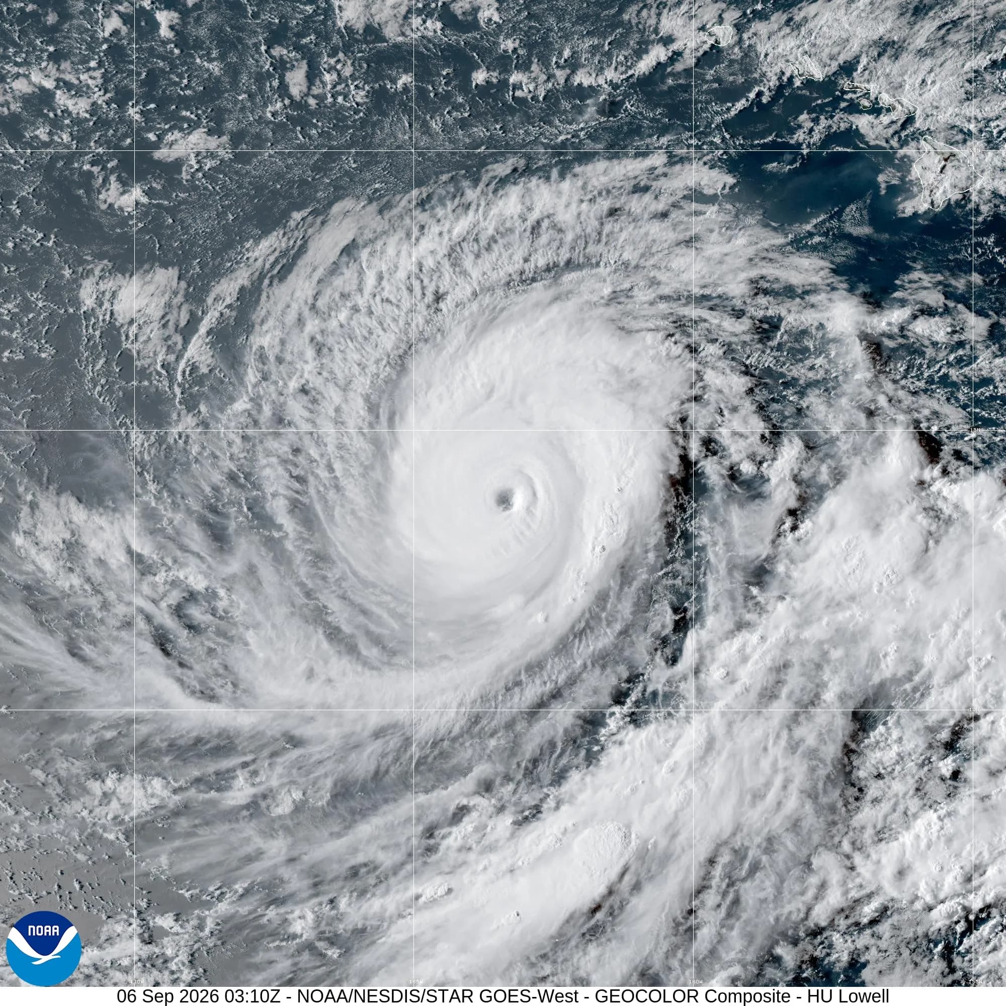
01飓风路径与强度监测Storm Track and Intensity Forecast
美国国家飓风中心最新通报显示,飓风“洛厄尔”目前保持四级飓风强度,最大持续风速达到每小时145英里。该气旋曾在周五夜间一度升至五级飓风,持续风速超过每小时157英里,随后在周六减弱至四级风力区间。风暴中心目前位于檀香山以西南偏南约640英里处,以每小时7英里的速度向西北偏西方向移动。
According to the National Hurricane Center, Hurricane Lowell is maintaining Category 4 status with maximum sustained winds of 145 mph. The cyclone had briefly strengthened into a Category 5 hurricane on Friday night with sustained winds of 157 mph or higher before losing some intensity and settling into Category 4 limits by Saturday. The storm was located approximately 640 miles south-southwest of Honolulu, moving west-northwest at 7 mph.
气象部门预计风暴将在周日及周一转向西北方向,并加速向北至东北偏北移动,在周一晚间掠过夏威夷主要群岛西侧。根据预测路径,风暴中心将穿过帕帕哈瑙莫夸基亚国家海洋保护区部分水域。气象专家指出,虽然“洛厄尔”在接近夏威夷期间预计会逐渐减弱,但仍将维持强飓风强度,若行进轨迹略微向东偏移,考艾岛等地遭遇的风雨强度将明显上升。
Forecasters project the storm will turn northwest before accelerating north and north-northeast through Sunday and Monday, passing just west of the main Hawaiian Islands on Monday night. The forecast track brings Lowell across portions of the Papahānaumokuākea Marine National Monument. Although gradual weakening is anticipated, meteorologists warn that Lowell is expected to remain near major hurricane strength during its closest approach, and any slight eastward shift in its path could bring significantly greater impacts and stronger winds to Kauai.
仅仅因为我们处于预测风暴锥的边缘,并不意味着我们就是安全的。
Just because we're on the edge of the cone doesn't mean we're safe.
约翰·布拉文德,美国国家气象局预警协调气象学家John Bravender, Warning Coordination Meteorologist at the National Weather Service
02暴雨、风暴潮与沿海巨浪威胁Heavy Rainfall, Storm Surge, and Coastal Hazards
美国国家气象局预测,夏威夷州多地将面临强降雨过程。考艾岛和大岛预计降雨量为3至6英寸,局部孤立地区雨量或将突破10英寸;茂宜岛预期降雨量为2至4英寸,局部山区可能接近8英寸;群岛其余地区的降水总量预计在1至2英寸之间。气象官员提醒,持续性强降水极易在山区诱发山洪暴发与泥石流灾害。
National Weather Service forecasts project widespread heavy rainfall across Hawaii. Kauai and the Big Island are expected to receive between 3 and 6 inches of rain, with isolated areas exceeding 10 inches, while Maui is forecast to see 2 to 4 inches, with localized amounts approaching 8 inches. Elsewhere in the state, rainfall totals are expected to range from 1 to 2 inches. Forecasters warn that the downpours could trigger dangerous flash flooding and mudslides, particularly across mountainous terrain.
沿海地区同样面临严重的海洋水文威胁。如果最高水位恰逢涨潮,考艾县的风暴潮预计将使水位比正常干燥地面高出1至3英尺,瓦胡岛水位则可能上升达1英尺。随着风暴逼近,考艾县可能在周一晚间迎来热带风暴天气,未来数天全州多处海岸线还将持续出现具有破坏力的大浪以及危及生命的离岸流。
Coastal regions also face significant marine hazards as Lowell passes. If the highest surge coincides with high tide, storm surge could raise water levels 1 to 3 feet above normally dry ground in Kauai County and up to 1 foot on Oahu. Tropical storm conditions remain possible in Kauai County by late Monday or Monday night, and large, destructive waves alongside life-threatening rip currents are forecast to impact shorelines across the state for several days.
03夏威夷州政府与应急防灾部署State Emergency Response and Public Preparedness
面对逼近的强风暴,夏威夷州政府在全州范围内启动防灾部署。州长办公室通报,州政府各部门正着手加固主要港口设施,向关键战略区域提前派遣应急响应人员,并持续对全州范围内的水坝进行严密监测,防范可能出现的溢流或溃坝险情。上个月热带风暴“拉拉”(Lala)曾在瓦胡岛和大岛局部引发强风暴雨与严重内涝,各级部门正加紧落实防御措施以应对新一轮风暴冲击。
In response to the approaching storm, Hawaii state agencies have initiated comprehensive protective operations. The governor's office stated that state authorities are securing key maritime harbors, prepositioning emergency personnel in strategic locations, and actively monitoring dams for potential overflows or structural breaches. These precautionary measures follow severe flooding and strong winds caused by Tropical Storm Lala, which impacted parts of Oahu and the Big Island last month, prompting heightened vigilance across the island chain.
美国国家气象局、国家海洋和大气管理局与应急管理机构联合发布居民防灾指引,呼吁公众充分利用周末窗口期完成各项准备工作。官方建议居民提前熟悉所在区域的疏散路线与避难规划,切勿涉水驾车,并在家中备足包含饮用水、应急食品、必备药品、手电筒和备用电池的应急物资包。此外,由于恶劣天气可能导致电力中断或通信受阻,应急部门提醒民众准备多种天气预警接收渠道并密切关注最新官方通报。
Emergency management officials alongside the National Weather Service and the National Oceanic and Atmospheric Administration advised residents to utilize the weekend window to finalize household storm preparedness. Officials recommended that residents identify their local evacuation zones, avoid driving through flooded roads, and assemble disaster kits containing water, non-perishable food, medications, flashlights, and extra batteries. Authorities also stressed maintaining multiple reliable ways to receive severe weather alerts in the event of widespread power outages or cellular service disruptions.
我们非常严肃地对待飓风‘洛厄尔’,并在情况恶化前立即做好准备。我敦促所有人,特别是考艾县的居民,尽快完成防灾准备,遵循官方预警,远离洪水、危险巨浪和其他危险区域。
We are taking Hurricane Lowell extremely seriously and preparing now, before conditions deteriorate. I urge everyone, especially those in Kauaʻi County, to complete their preparations, follow official alerts and stay away from floodwaters, dangerous surf and other hazardous areas.
乔什·格林,夏威夷州州长Josh Green, Governor of Hawaii
04太平洋多风暴共存与气候背景Pacific Cyclone Activity and Climate Drivers
在飓风“洛厄尔”逼近夏威夷的同时,北太平洋海域本周还同时存在另外两个活跃的热带气旋系统。曾达到四级飓风强度的“卡琳娜”(Karina)位于夏威夷希洛以东北偏东约755英里处,而热带风暴“玛丽”(Marie)则在下加利福尼亚半岛南端以西约705英里的洋面上活动。美国国家飓风中心气象专家指出,“玛丽”可能在假日周末为南加利福尼亚州沿海带来巨浪。根据科罗拉多州立大学的数据,这三个气旋使东北太平洋本季度已命名风暴的总数达到15个。
Alongside Hurricane Lowell, two other active tropical cyclones are churning across the northern half of the Pacific this week. Karina, a former Category 4 hurricane, was located roughly 755 miles east-northeast of Hilo, Hawaii, while Tropical Storm Marie was spinning about 705 miles west of the southern tip of Baja California. National Hurricane Center meteorologists noted that Marie could generate high surf along the Southern California coast over the holiday weekend. According to data from Colorado State University, these storms bring the Northeast Pacific hurricane season count to 15 named storms to date.
专家分析指出,异常偏暖的海水温度以及厄尔尼诺现象为风暴活动提供了强劲动力。非营利研究机构“气候中心”(Climate Central)的气象与大气科学家丹尼尔·吉尔福德(Daniel Gilford)表示,厄尔尼诺带来的暖海面水温在入秋前为强效热带气旋注入能量,充沛的能量让风暴变得更加猛烈。地球科学专家同时提到全球变暖正在改变这种气候模式,联合国秘书长古特雷斯表示,厄尔尼诺现象正在加剧扩大,呼吁各方加快采取行动应对气候变化。
Experts attribute the elevated storm frequency and intensity to unusually warm ocean waters and the influence of an El Niño weather pattern. Daniel Gilford, a meteorologist and atmospheric scientist at the nonprofit research organization Climate Central, stated that warm sea surface temperatures associated with El Niño provide fuel for potent tropical cyclones ahead of autumn. Earth scientists note that global warming is altering these natural phenomena, with United Nations Secretary-General António Guterres warning that El Niño is being supersized before our eyes and urging decisive action to tackle climate change.
如果我们拥有额外的燃料,就可以把油门踩得更深,这些风暴也会因此变得更加强烈。
If we have extra fuel, we can push the accelerator down more and these storms can become more intense as a result.
丹尼尔·吉尔福德,非营利研究机构“气候中心”气象与大气科学家(接受NBC新闻采访)Daniel Gilford, meteorologist and atmospheric scientist at Climate Central (speaking to NBC News)